Praia do Forte da Barra Beach
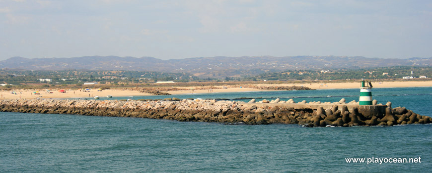
View to Praia do Forte da Barra Beach, from the Gilão River mouth.
Weather and Tide Table
Full Moon
Fair
20h49
Sunset
Sunset
06h10
Sunrise
Sunrise
Seg
19 - 31
Ter
19 - 28
Qua
20 - 26
Qui
18 - 29
Sex
17 - 22
26
ºC
Air Temperature
WSW
14
km/h
Wind Speed and Direction
44
%
Relative Humidity
1011
mbar
Atmospheric Pressure
No Data
No Data
No Data
No Data
Water Temperature
No Data
Wave Direction
No Data
Wave Medium Height
No Data
Wave Medium Period
0% | 3,3 m 10.8 ft | High Tide | |
1% | 0,9 m 3 ft | Low Tide | |
1% | 3,3 m 10.8 ft | High Tide | |
2% | 0,9 m 3 ft | Low Tide | |
2% | 3,3 m 10.8 ft | High Tide | |
3% | 0,9 m 3 ft | Low Tide | |
4% | 3,2 m 10.5 ft | High Tide | |
5% | 0,9 m 3 ft | Low Tide | |
6% | 3,3 m 10.8 ft | High Tide | |
7% | 1,0 m 3.3 ft | Low Tide | |
9% | 3,1 m 10.2 ft | High Tide | |
10% | 1,0 m 3.3 ft | Low Tide | |
12% | 3,2 m 10.5 ft | High Tide | |
13% | 1,1 m 3.6 ft | Low Tide | |
15% | 3,0 m 9.8 ft | High Tide | |
17% | 1,2 m 3.9 ft | Low Tide | |
19% | 3,1 m 10.2 ft | High Tide | |
20% | 1,2 m 3.9 ft | Low Tide | |
22% | 2,9 m 9.5 ft | High Tide | |
24% | 1,3 m 4.3 ft | Low Tide | |
27% | 3,0 m 9.8 ft | High Tide | |
29% | 1,4 m 4.6 ft | Low Tide | |
31% | 2,7 m 8.9 ft | High Tide | |
33% | 1,5 m 4.9 ft | Low Tide | |
36% | 2,8 m 9.2 ft | High Tide | |
38% | 1,6 m 5.2 ft | Low Tide | |
41% | 2,6 m 8.5 ft | High Tide | |
43% | 1,7 m 5.6 ft | Low Tide | |
46% | 2,8 m 9.2 ft | High Tide | |
49% | 1,7 m 5.6 ft | Low Tide | |
52% | 2,5 m 8.2 ft | High Tide | |
54% | 1,8 m 5.9 ft | Low Tide | |
57% | 2,8 m 9.2 ft | High Tide | |
60% | 1,6 m 5.2 ft | Low Tide | |
63% | 2,6 m 8.5 ft | High Tide | |
65% | 1,7 m 5.6 ft | Low Tide | |
68% | 2,9 m 9.5 ft | High Tide | |
70% | 1,4 m 4.6 ft | Low Tide | |
73% | 2,8 m 9.2 ft | High Tide | |
75% | 1,5 m 4.9 ft | Low Tide | |
78% | 3,1 m 10.2 ft | High Tide | |
80% | 1,2 m 3.9 ft | Low Tide | |
83% | 3,1 m 10.2 ft | High Tide | |
About the Beach
What is Praia do Forte da Barra Beach?
It's an Oceanic Beach in the northern hemisphere bathed by the Atlantic Ocean, located on the coast of Portugal - Iberian Peninsula - in the municipality of Tavira.
Praia do Forte da Barra Beach has a very extensive sand of about 1,4 Km.
It lies at Ilha de Cabanas1 and belongs to the Parque Natural da Ria Formosa2 territory.
I the northeast, the beach is bounded by the Ribeira do Almargem3 mouth and in the west by the east pontoon of the Rio Gilão4 mouth. There are plus three minor piers also in this area.
A little more than half kilometer far away, after the Canal de Tavira5, Forte do Rato6 can be sighted.
References
- Cabanas Island
- Formosa River Natural Park
- Almargem Stream
- Gilão River
- Tavira Canal
- Rato Fort
Where is it?
Map of Praia do Forte da Barra Beach
| Coordinates Decimal Degrees (Lat/Long WGS84) Degrees, Decimal Minutes (Lat/Long WGS84) Degrees, Minutes, Seconds (Lat/Long WGS84) |
Lat. 37.118494º Lon. -7.616114º N 37º 7.10964' W 7º 36.96684' N 37º 7' 6.58" W 7º 36' 58.01" |
| Parish | Santa Maria |
| County | Tavira |
| District | Faro |
| Region | Algarve |
| Country | Portugal |
| Continent | Europe |
| Ocean | North Atlantic |
| Maritime Authority | Capitania do Porto de Tavira |
| Protected Area | Parque Natural da Ria Formosa |
| Bathing Water | |
| Coastal Unit | Cabo Santa Maria - Manta Rota |
| Coastal Region | Costa Algarvia |
Awards
| Award | 2017 | 2016 | 2015 | 2014 | 2013 | 2012 | 2011 | 2010 | 2009 | 2008 | 2007 | 2006 |
|---|---|---|---|---|---|---|---|---|---|---|---|---|
| Water Quality | ||||||||||||
| Blue Flag | ||||||||||||
| Gold Flag | ||||||||||||
| Handicapped-Accessible Beach | ||||||||||||
| Zero Polution |
Reviews
Login to Review.
or start session at
.