Praia da Malha da Costa Beach
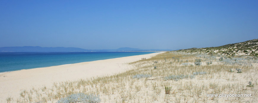
North perspective of Praia da Malha da Costa Beach.
Weather and Tide Table
Waxing Gibbous Moon
Blustery
06h11
Sunrise
Sunrise
20h58
Sunset
Sunset
Seg
11 - 28
Ter
14 - 27
Qua
15 - 26
Qui
15 - 23
Sex
15 - 20
21
ºC
Air Temperature
N
31
km/h
Wind Speed and Direction
51
%
Relative Humidity
1017
mbar
Atmospheric Pressure
No Data
No Data
No Data
No Data
Water Temperature
SW
Wave Direction
0.42
m
Wave Medium Height
3.9
s
Wave Medium Period
0% | 3,2 m 10.5 ft | High Tide | |
1% | 0,8 m 2.6 ft | Low Tide | |
1% | 3,2 m 10.5 ft | High Tide | |
2% | 0,8 m 2.6 ft | Low Tide | |
2% | 3,2 m 10.5 ft | High Tide | |
3% | 0,8 m 2.6 ft | Low Tide | |
4% | 3,1 m 10.2 ft | High Tide | |
5% | 0,9 m 3 ft | Low Tide | |
6% | 3,2 m 10.5 ft | High Tide | |
7% | 0,9 m 3 ft | Low Tide | |
9% | 3,0 m 9.8 ft | High Tide | |
10% | 1,0 m 3.3 ft | Low Tide | |
12% | 3,1 m 10.2 ft | High Tide | |
13% | 1,0 m 3.3 ft | Low Tide | |
15% | 2,9 m 9.5 ft | High Tide | |
17% | 1,1 m 3.6 ft | Low Tide | |
19% | 3,0 m 9.8 ft | High Tide | |
20% | 1,1 m 3.6 ft | Low Tide | |
22% | 2,7 m 8.9 ft | High Tide | |
24% | 1,3 m 4.3 ft | Low Tide | |
27% | 2,8 m 9.2 ft | High Tide | |
29% | 1,3 m 4.3 ft | Low Tide | |
31% | 2,6 m 8.5 ft | High Tide | |
33% | 1,4 m 4.6 ft | Low Tide | |
36% | 2,7 m 8.9 ft | High Tide | |
39% | 1,4 m 4.6 ft | Low Tide | |
41% | 2,4 m 7.9 ft | High Tide | |
43% | 1,6 m 5.2 ft | Low Tide | |
46% | 2,6 m 8.5 ft | High Tide | |
49% | 1,5 m 4.9 ft | Low Tide | |
52% | 2,4 m 7.9 ft | High Tide | |
54% | 1,6 m 5.2 ft | Low Tide | |
57% | 2,6 m 8.5 ft | High Tide | |
60% | 1,4 m 4.6 ft | Low Tide | |
63% | 2,5 m 8.2 ft | High Tide | |
65% | 1,5 m 4.9 ft | Low Tide | |
68% | 2,7 m 8.9 ft | High Tide | |
70% | 1,3 m 4.3 ft | Low Tide | |
73% | 2,7 m 8.9 ft | High Tide | |
75% | 1,3 m 4.3 ft | Low Tide | |
78% | 2,9 m 9.5 ft | High Tide | |
80% | 1,0 m 3.3 ft | Low Tide | |
83% | 2,9 m 9.5 ft | High Tide | |
About the Beach
What is Praia da Malha da Costa Beach?
It's an Oceanic Beach in the northern hemisphere bathed by the Atlantic Ocean, located on the coast of Portugal - Iberian Peninsula - in the municipality of Grândola.
Praia da Malha da Costa Beach has a very extensive sand of about 3,2 Km ,along the full length of the only oceanic area of the Reserva Natural do Estuário do Sado1. It's located in the surroundings of WWTP1 Tróia.
The dune system of this beach is immense and as one moves away from the Atlantic Ocean into east, the vegetation becomes denser.
At east, less than 1 Km away, may be sighted the Rio Sado3 and its farm lands, full of rice paddies in a smaller peninsula.
References
- Sado Estuary Natural Reserve
- Wastewater Treatment Plant
- Sado River
Where is it?
Map of Praia da Malha da Costa Beach
| Coordinates Decimal Degrees (Lat/Long WGS84) Degrees, Decimal Minutes (Lat/Long WGS84) Degrees, Minutes, Seconds (Lat/Long WGS84) |
Lat. 38.424379º Lon. -8.828994º N 38º 25.46274' W 8º 49.73964' N 38º 25' 27.76" W 8º 49' 44.38" |
| Parish | Carvalhal |
| County | Grândola |
| District | Setúbal |
| Region | Baixo Alentejo |
| Country | Portugal |
| Continent | Europe |
| Ocean | North Atlantic |
| Maritime Authority | Capitania do Porto de Setúbal |
| Protected Area | Reserva Natural do Estuário do Sado |
| Bathing Water | |
| Coastal Unit | Outão - Praia da Rapousa (Pinheiro da Cruz) |
| Coastal Region | Costa Azul |
Awards
| Award | 2017 | 2016 | 2015 | 2014 | 2013 | 2012 | 2011 | 2010 | 2009 | 2008 | 2007 | 2006 |
|---|---|---|---|---|---|---|---|---|---|---|---|---|
| Water Quality | ||||||||||||
| Blue Flag | ||||||||||||
| Gold Flag | ||||||||||||
| Handicapped-Accessible Beach | ||||||||||||
| Zero Polution |
Documents
Reviews
Login to Review.
or start session at
.