Prainha Beach
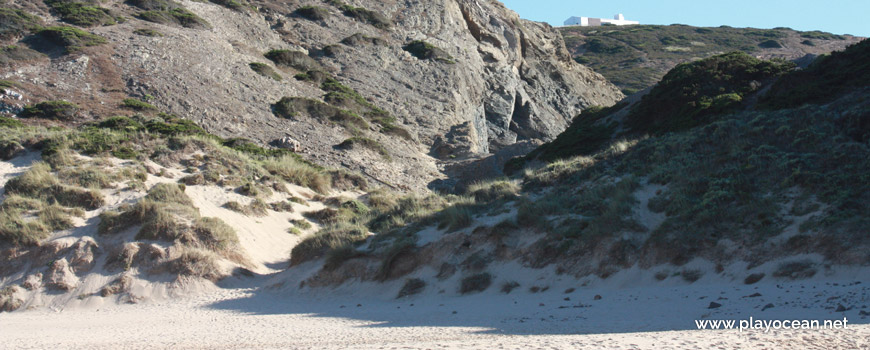
Access ravine to Prainha Beach.
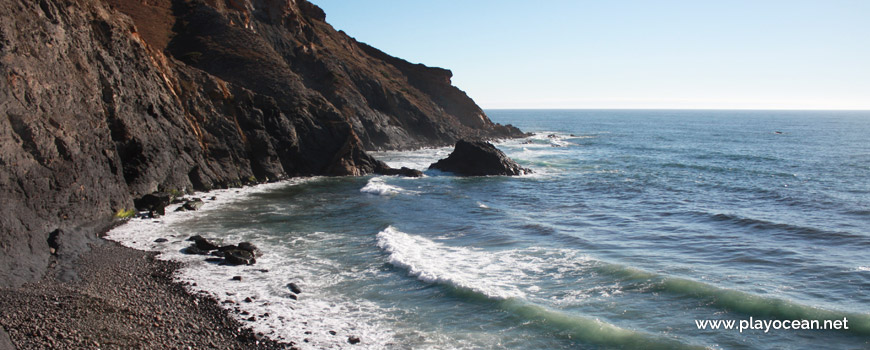
Prainha Beach during high tide.
Weather and Tide Table
Waning Gibbous Moon
Partly Cloudy
06h14
Sunrise
Sunrise
20h55
Sunset
Sunset
Seg
13 - 24
Ter
16 - 23
Qua
15 - 22
Qui
13 - 20
Sex
14 - 19
18
ºC
Air Temperature
N
16
km/h
Wind Speed and Direction
63
%
Relative Humidity
1007
mbar
Atmospheric Pressure
No Data
No Data
No Data
No Data
Water Temperature
No Data
Wave Direction
No Data
Wave Medium Height
No Data
Wave Medium Period
0% | 3,2 m 10.5 ft | High Tide | |
1% | 0,8 m 2.6 ft | Low Tide | |
1% | 3,2 m 10.5 ft | High Tide | |
2% | 0,8 m 2.6 ft | Low Tide | |
2% | 3,2 m 10.5 ft | High Tide | |
3% | 0,8 m 2.6 ft | Low Tide | |
4% | 3,1 m 10.2 ft | High Tide | |
5% | 0,9 m 3 ft | Low Tide | |
6% | 3,2 m 10.5 ft | High Tide | |
7% | 0,9 m 3 ft | Low Tide | |
9% | 3,0 m 9.8 ft | High Tide | |
10% | 1,0 m 3.3 ft | Low Tide | |
12% | 3,1 m 10.2 ft | High Tide | |
13% | 1,0 m 3.3 ft | Low Tide | |
15% | 2,9 m 9.5 ft | High Tide | |
17% | 1,1 m 3.6 ft | Low Tide | |
19% | 3,0 m 9.8 ft | High Tide | |
20% | 1,1 m 3.6 ft | Low Tide | |
22% | 2,7 m 8.9 ft | High Tide | |
24% | 1,3 m 4.3 ft | Low Tide | |
27% | 2,8 m 9.2 ft | High Tide | |
29% | 1,3 m 4.3 ft | Low Tide | |
31% | 2,6 m 8.5 ft | High Tide | |
33% | 1,4 m 4.6 ft | Low Tide | |
36% | 2,7 m 8.9 ft | High Tide | |
39% | 1,4 m 4.6 ft | Low Tide | |
41% | 2,4 m 7.9 ft | High Tide | |
43% | 1,6 m 5.2 ft | Low Tide | |
46% | 2,6 m 8.5 ft | High Tide | |
49% | 1,5 m 4.9 ft | Low Tide | |
52% | 2,4 m 7.9 ft | High Tide | |
54% | 1,6 m 5.2 ft | Low Tide | |
57% | 2,6 m 8.5 ft | High Tide | |
60% | 1,4 m 4.6 ft | Low Tide | |
63% | 2,5 m 8.2 ft | High Tide | |
65% | 1,5 m 4.9 ft | Low Tide | |
68% | 2,7 m 8.9 ft | High Tide | |
70% | 1,3 m 4.3 ft | Low Tide | |
73% | 2,7 m 8.9 ft | High Tide | |
75% | 1,3 m 4.3 ft | Low Tide | |
78% | 2,9 m 9.5 ft | High Tide | |
80% | 1,0 m 3.3 ft | Low Tide | |
83% | 2,9 m 9.5 ft | High Tide | |
About the Beach
What is Prainha Beach?
It's an Oceanic Beach in the northern hemisphere bathed by the Atlantic Ocean, located on the coast of Portugal - Iberian Peninsula - in the municipality of Aljezur.
Prainha Beach has a very small sand with the shape of a seashell.
The surrounding cliff protects it from the wind and transforms it into a cosy corner.
Nearby, flows the Ribeira do Barranco de Vale Figueira1.
In order to attend this beach it is necessary to pay attention to tidal periods, since the sea covers all the beach during high tide.
The access is through the sand of the north neighboring beach, during low tide.
References
- Barranco de Vale Figueira Stream
Where is it?
Map of Prainha Beach
| Coordinates Decimal Degrees (Lat/Long WGS84) Degrees, Decimal Minutes (Lat/Long WGS84) Degrees, Minutes, Seconds (Lat/Long WGS84) |
Lat. 37.160613º Lon. -8.906626º N 37º 9.63678' W 8º 54.39756' N 37º 9' 38.21" W 8º 54' 23.85" |
| Parish | Bordeira |
| County | Aljezur |
| District | Faro |
| Region | Algarve |
| Country | Portugal |
| Continent | Europe |
| Ocean | North Atlantic |
| Maritime Authority | Capitania do Porto de Lagos |
| Protected Area | Parque Natural do Sudoeste Alentejano e Costa Vicentina |
| Bathing Water | |
| Coastal Unit | Pontal - Cabo São Vicente |
| Coastal Region | Costa Vicentina |
Awards
| Award | 2017 | 2016 | 2015 | 2014 | 2013 | 2012 | 2011 | 2010 | 2009 | 2008 | 2007 | 2006 |
|---|---|---|---|---|---|---|---|---|---|---|---|---|
| Water Quality | ||||||||||||
| Blue Flag | ||||||||||||
| Gold Flag | ||||||||||||
| Handicapped-Accessible Beach | ||||||||||||
| Zero Polution |
Reviews
Login to Review.
or start session at
.