Praia do Porto das Barcas Beach
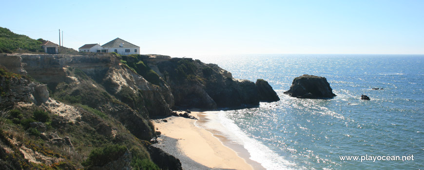
South perspective at Praia do Porto das Barcas Beach.
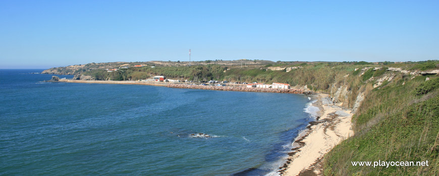
Panoramic view over Praia do Porto das Barcas Beach.
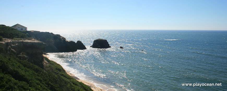
Rocky cliff and and an islet on the south part.
Weather and Tide Table
Sunset
Sunrise
0% | 3,2 m 10.5 ft | High Tide | |
1% | 0,8 m 2.6 ft | Low Tide | |
1% | 3,2 m 10.5 ft | High Tide | |
2% | 0,8 m 2.6 ft | Low Tide | |
2% | 3,2 m 10.5 ft | High Tide | |
3% | 0,8 m 2.6 ft | Low Tide | |
4% | 3,1 m 10.2 ft | High Tide | |
5% | 0,9 m 3 ft | Low Tide | |
6% | 3,2 m 10.5 ft | High Tide | |
7% | 0,9 m 3 ft | Low Tide | |
9% | 3,0 m 9.8 ft | High Tide | |
10% | 1,0 m 3.3 ft | Low Tide | |
12% | 3,1 m 10.2 ft | High Tide | |
13% | 1,0 m 3.3 ft | Low Tide | |
15% | 2,9 m 9.5 ft | High Tide | |
17% | 1,1 m 3.6 ft | Low Tide | |
19% | 3,0 m 9.8 ft | High Tide | |
20% | 1,1 m 3.6 ft | Low Tide | |
22% | 2,7 m 8.9 ft | High Tide | |
24% | 1,3 m 4.3 ft | Low Tide | |
27% | 2,8 m 9.2 ft | High Tide | |
29% | 1,3 m 4.3 ft | Low Tide | |
31% | 2,6 m 8.5 ft | High Tide | |
33% | 1,4 m 4.6 ft | Low Tide | |
36% | 2,7 m 8.9 ft | High Tide | |
39% | 1,4 m 4.6 ft | Low Tide | |
41% | 2,4 m 7.9 ft | High Tide | |
43% | 1,6 m 5.2 ft | Low Tide | |
46% | 2,6 m 8.5 ft | High Tide | |
49% | 1,5 m 4.9 ft | Low Tide | |
52% | 2,4 m 7.9 ft | High Tide | |
54% | 1,6 m 5.2 ft | Low Tide | |
57% | 2,6 m 8.5 ft | High Tide | |
60% | 1,4 m 4.6 ft | Low Tide | |
63% | 2,5 m 8.2 ft | High Tide | |
65% | 1,5 m 4.9 ft | Low Tide | |
68% | 2,7 m 8.9 ft | High Tide | |
70% | 1,3 m 4.3 ft | Low Tide | |
73% | 2,7 m 8.9 ft | High Tide | |
75% | 1,3 m 4.3 ft | Low Tide | |
78% | 2,9 m 9.5 ft | High Tide | |
80% | 1,0 m 3.3 ft | Low Tide | |
83% | 2,9 m 9.5 ft | High Tide | |
About the Beach
What is Praia do Porto das Barcas Beach?
It's an Oceanic Beach in the northern hemisphere bathed by the Atlantic Ocean, located on the coast of Portugal - Iberian Peninsula - in the municipality of Odemira.
Praia do Porto das Barcas Beach discloses a very long strip of sand intersected by groups of pebbles. It is also known as Praia do Portinho do Canal Beach for being right beside an harbor called Portinho de Pesca de Vila Nova de Milfontes1.
The beach is east flanked by a rocky cliff.
During low tide a vast area of rocks emerges from the sea water. About 400 meters away from the shore may be sighted some large boulders.
The access is via the Estrada do Canal2, coming from Vila Nova de Milfontes town.
References
- Vila Nova de Milfontes fishing harbor
- Canal Road
Where is it?
Map of Praia do Porto das Barcas Beach
| Coordinates Decimal Degrees (Lat/Long WGS84) Degrees, Decimal Minutes (Lat/Long WGS84) Degrees, Minutes, Seconds (Lat/Long WGS84) |
Lat. 37.732434º Lon. -8.796596º N 37º 43.94604' W 8º 47.79576' N 37º 43' 56.76" W 8º 47' 47.75" |
| Parish | Vila Nova de Milfontes |
| County | Odemira |
| District | Beja |
| Region | Baixo Alentejo |
| Country | Portugal |
| Continent | Europe |
| Ocean | North Atlantic |
| Maritime Authority | Capitania do Porto de Sines |
| Protected Area | Parque Natural do Sudoeste Alentejano e Costa Vicentina |
| Bathing Water | |
| Coastal Unit | São Torpes (N) - Pedra da Foz (Vila Nova de Milfontes) |
| Coastal Region | Costa Vicentina |
Awards
| Award | 2017 | 2016 | 2015 | 2014 | 2013 | 2012 | 2011 | 2010 | 2009 | 2008 | 2007 | 2006 |
|---|---|---|---|---|---|---|---|---|---|---|---|---|
| Water Quality | ||||||||||||
| Blue Flag | ||||||||||||
| Gold Flag | ||||||||||||
| Handicapped-Accessible Beach | ||||||||||||
| Zero Polution |